Mosquito Fire Information
Information Line: 211
Media Line: (530) 217 – 3263
Incident email: MosquitoFire2022@gmail.com
El Dorado County Incident Page
Incident Website: www.fire.ca.gov
Placer County Sheriff’s Office Facebook
El Dorado County Sheriff’s Office Facebook
National Weather Service
Evacuation Preparedness
Returning Home Checklist
EL DORADO COUNTY EVACUATION MAP
Updated September 10, 2022: El Dorado County Evacuation Orders and Warnings
The descriptions and boundaries of the evacuation zones are taken directly from the interactive evacuation map that the El Dorado County Sheriff’s Office manages and updates.
Evacuation Orders are in effect for the following areas:
Name: Volcanoville
North of Wentworth Springs, east of Otter Creek, south of the county line, and west of Tunnel Hill Road
Name: Quintette
North of Wentworth Springs, east of Lofty Peak Lane, south of county line, and west of Blackeye Pea Road
Name: Bald Mountain
East of Breedlove Road (including both sides of Wentworth Springs Road) and West of Stumpy Meadows Lake
Name: Grey Eagle
East of Breedlove Road (including both sides of Wentworth Springs Road) and west of Stumpy Meadows Lake
Name: Canyon Creek
East of Greenwood Road, south of the county line, and north of Meadow Brooke Road
Name: Georgetown
Evacuation Warnings are in effect for the following areas: Name: Cool
Name: Garden Valley
Name: Swansboro / Slate Mountain Name: East Stumpy Meadows
MOSQUITO FIRE EL DORADO COUNTY EVACUATION UPDATES There is an EVACUATION WARNING in the in the area of Stumpy Meadows.
• East of Stumpy Meadows
• West of Loon Lake
• South of the County border
• North of Little Silver Creek
There is an EVACUATION WARNING in the area of Slate Mountain, including Swansboro.
• East of Garden Valley
• South of Sand Mountain
• North of the Mosquito Bridge
• West of Traverse Creek There is an EVACUATION WARNING in the area of Cool. • East of Highway 49
• South of the County Line
• North of Highway 49/Coloma Road
• West of Greenwood Road
El Dorado County has opened an overnight shelter for Mosquito Fire evacuees at Cameron Park Services District, 2502 Country Club Drive, Cameron Park, CA 95682.
Overnight shelter, meals, showers, limited health services, and parking for trailers will be provided. Animals in crates and carriers will be accepted. Please be prepared to evacuate IF the Evacuation Warning becomes an Evacuation Order.
Those who require additional time to evacuate, including those with pets and livestock, should consider leaving now. For all information regarding evacuations, shelters, and the Mosquito Fire, please visit the El Dorado County Website at https://bit.ly/3ATtqao.
TEMPORARY EVACUATION POINT A Temporary Evacuation Point has reopened at Cool Community Church at 863 Cave Valley Rd., Cool, CA 95614 as a place for those impacted by the #MosquitoFire to gather to determine their next steps. This location will accommodate evacuees and their domestic animals except for birds (due to a potential for Avian Flu), temporarily, until more permanent evacuation centers become available.
Caldor Fire Information
El Dorado County Caldor Fire Information: https://edcgov.us/Pages/Caldor-Fire.aspx
Cal Fire Information: https://www.fire.ca.gov/incidents/2021/8/14/caldor-fire
Donate to the El Dorado Community Foundation Relief Fund to help with Caldor Fire relief efforts. Donate here>>
Air Quality Information: https://www.purpleair.com
As of October 21, 2021, the Caldor Fire is 100% contained.
Highway 50 is now open to South Lake Tahoe in both directions.
FOREST CLOSURES:
Lake Tahoe Basin Management Unit: The backcountry closure was terminated on October 14, 2021.
Eldorado National Forest Closure: The forest closure was revised on October 15, 2021. See the full closure details and map here.
Update September 2, 2021 – Caldor Fire Update
Apple Hill Growers Association
Apple Hill Growers will be opening their farm stands and bakeshops on Labor Day Weekend and many visitors have questions regarding the effect of the Caldor Fire. We are happy to report that none of the growers sustained any damage and in fact, fire crews were able to hold the fire line well to the south of Apple Hill Growers and we are grateful to all our fire crews who worked so hard to keep us safe.
Highway 50 is still closed from Pollock Pines to the California / Nevada State line.
Please be kind to our locals, obey traffic and parking laws, our community has endured so much during this difficult time.
**EVACUATION ORDERS DOWNGRADED**
The following Evacuation Orders in the areas of North Camino and Pollock Pines described below have been downgraded to an Evacuation Warning:
North of Highway 50, West of Sly Park, South of Slab Creek, and East of Larsen Drive / Snows Road.
NOTES: El Dorado Irrigation District officials request that evacuated residents with water service provided by EID consider running internal taps for a couple of minutes upon returning to ensure fresh water in their homes. Water that has remained in service lines during evacuation periods can result in customers detecting taste and odor issues that may be easily addressed by flushing the taps. EID’s water is safe to drink. The main distribution system piping was not affected by fire and the integrity of the overall system has not been affected, as confirmed by its ongoing and rigorous water quality testing program.
All previous evacuation orders and warnings remain in effect.
Update August 30, 2021 – Caldor Fire Update
**EVACUATION ORDER 11:30 am:**
El Dorado County
Heavenly
• East of Pioneer Trail between Larch and Al Tahoe, to include the area of Heavenly Ski Resort out
to the Alpine County Line and the Nevada State line on the East.
Stateline
• East of Ski Run on the lakeside of Pioneer Trail and also both sides of Pioneer Trail between Larch
and the Nevada State line.
Evacuation Routes:
• Evacuate Eastbound on Highway 50 towards Nevada.
Evacuation Shelters:
• Truckee Veterans Hall 10214 High Street, Truckee, CA 96161
• Douglas County Community Center, 1329 Waterloo Lane, Gardnerville, NV
**EVACUATION ORDER 10:55 am**
El Dorado County
Tahoe Keys
• All residences with the Tahoe Keys community and all residents accessed from the streets connected to Tahoe Keys Blvd, staying east of 3rd Street.
Tahoe Island
• East of Highway 50/ Highway 89 at the Lake Tahoe Blvd and Highway 89 Highway 50 intersection. This includes the area of Barton Hospital and the area of Winnemucca to the “Y”. Also north of Highway 50 west of Tahoe Keys Blvd following along the north side of Highway 89 through the end of town prior to Pope Beach.
Al Tahoe
• All residences off of Lakeview which is west of Highway 50 North of Blue Lakes Road and east of Tahoe Keys Neighborhood. Sierra Tract
• All residences on both sides of Highway 50 for the streets connected to O’Malley, Lodi, Silver Dollar, and Rubicon Trail.
Bijou
• The residences between Al Tahoe on the east side of Johnson Blvd to include the streets of Treehaven and Fremont and extending to the east into all residences west of Ski Run and east of Pioneer Trail.
EVACUATION ROUTES
• Evacuate Eastbound on Highway 50 towards Nevada.
EVACUATION SHELTERS
• Truckee Veterans Hall 10214 High Street, Truckee, CA 96161
• Douglas County Community Center, 1329 Waterloo Lane, Gardnerville, NV
Please go to: www.tinyurl.com/EDSOEVAC for an online evacuation map.
All previous evacuation orders and warnings remain in effect.
**EVACUATION ORDER 9:30 am **
EL DORADO COUNTY
Tahoma
• The section from Emerald Bay north to the Placer county line in Tahoma, extending west to the border of Desolation Wilderness.
Fallen Leaf
• The area from Sawmill Road at Lake Tahoe Blvd. extending north to Pope Beach. Along the water’s edge to Eagle Point. From Eagle Point west to Desolation Wilderness, across Emerald Bay.
Pioneer
• This is the area North of Elks Club along Highway 50 and the West side of Pioneer Trail, also including the streets of Hekpa, excluding the residences west of the airport, this segment includes all residences accessed from Jicarilla, Washoan, and Glen Eagles. This also includes the Golden Bear neighborhood, and the neighborhoods of Cold Creek Trail, High Meadows, and Marshall Trail.
Gardner Mountain
• Northwest of the South Lake Tahoe Airport and west of Highway 50 / Lake Tahoe Blvd and Highway 89 intersection to include the South Lake Tahoe High School, Tahoe Verde, and the streets accessed from 5th through 15th street south of Highway 89
Trimmer
• The area East of Pioneer Trail to the Alpine County Line stopping South of Heavenly Ski Resort, excluding all residences off of Pioneer Trail.
EVACUATION ROUTES
• For the areas of Fallen Leaf and Tahoma go North on Highway 89 towards Truckee.
• For all other areas, evacuate Eastbound on Highway 50 towards Nevada.
EVACUATION SHELTERS
• Truckee Veterans Hall
10214 High Street, Truckee, CA 96161
• A Red Cross Shelter is open for those evacuating from the area at the Douglas County Community Center, 1329 Waterloo Lane, Gardnerville, NV
Update August 29, 2021 – Caldor Fire Update
**EVACUATION ORDER**
El Dorado County
Desolation Wilderness from the watershed ridge to the CA ENF/CA TMU wilderness boundary. From the El Dorado/Placer county line to Echo Lakes.
**EVACUATION WARNING:**
El Dorado County
The remaining area of the Lake Tahoe Basin. From the Alpine/El Dorado county line, north along the California/Nevada state line to Lake Tahoe. North along the water’s edge to the El Dorado/Placer county line. West along the El Dorado/Placer county line to McKinney Lake.
ROAD CLOSURES:
- Highway 50 is closed between Pollock Pines to Sawmill Road.
- Highway 88 is closed from Omo Ranch Road to Highway 89 intersection.
- Highway 50 at Sawmill
- Pioneer Trail at Elks Club
- Elks Club at Highway 50
- Highway 89 at Highway 88 junction
- Fallen Leaf at Tahoe Mountain
Update August 27, 2021 – Caldor Fire Information
Evacuation Order:
El Dorado County
• Pleasant Valley Road and all intersecting roads extending south from Newtown Road to the intersection of E-16 (Mt Aukum Road).
• All roads accessed from E-16 (Mt Aukum Road) between Pleasant Valley Road and Bucks Bar Road.
• This includes all roads and residences accessed from Moon-Shadow and Gopher Hole Road off Bucks Bar Road.
NOTES:
This Evacuation Order does not include the residences off Pleasant Valley Road West of Newtown Road to include Pleasant Valley Middle School, Michael Way, and all roads to Four Seasons Road
Please go to: www.tinyurl.com/EDSOEVAC for an online evacuation map.
Update August 23, 2021 – Caldor Fire Information
U.S. Highway 50 is CLOSED in both directions between Sly Park Road and Twin Bridges. Highway 50 will be open between Meyers and Twin Bridges for local residents only who reside between Meyers and Twin Bridges. Mandatory evacuations are now in place between Sly Park and Strawberry.
Please note there are no evacuation orders for South Lake Tahoe.
U.S. Highway 50 is the main route from the Sacramento area to South Lake Tahoe. Drivers heading for Tahoe should take Interstate 80.
Check Caltrans for current highway road conditions and the Cal Fire incident page for updates on the wildfire.
Find out air quality conditions in the area here.
Other important closures:
- The Rubicon Trail is closed until further notice due to the Caldor Fire and the U.S. Forest Service order. Emergency response personnel are unavailable, so please respect this closure.
- The El Dorado National Forest is closed for public and firefighter safety until September 30, 2021.
- Many wineries, farms, and local attractions are currently closed due to the fire and evacuations. Please contact them directly to confirm their operating hours.
Update August 20, 2021 – Caldor Fire Information + Evacuations
UPDATE: Highway 50 is set to be CLOSED at 4:30 pm today in both directions between Sly Park Road and Twin Bridges. Highway 50 will be open between Meyers and Twin Bridges for local residents only who reside between Meyers and Twin Bridges. No traffic will be allowed west past Twin Bridges. This closure is due to safety concerns with high winds expected to impact the Caldor FIre. Mandatory evacuations are now in place between Sly Park and Strawberry.
Please note there are no evacuation orders for South Lake Tahoe.
Update August 19, 2021 – Caldor Fire Information + Evacuations
The El Dorado National Forest is closed for public and firefighter safety until September 30, 2021. Please respect the closure.
The Rubicon Trail is closed until further notice due to the Caldor fire and the Forest Service order. See more information.
Many wineries, farms, and local attractions are currently closed due to the fire and evacuations. Please contact them directly to confirm their operating hours.
Update August 18, 2021 – Caldor Fire Information + Evacuations
EVACUATION CENTER:
New additional evacuation site.
Cold Springs Community Church
2600 Cold Springs Rd, Placerville, CA 95667
They have room for RVs and motorhomes and can house evacuees.
All of Eldorado national forest is closed due to fire danger and the need for emergency vehicles to access.
Hwy 50, 49, and 88 are all open at this time. Avoid Highway 50 unless necessary.
The communities of Pollock Pines, Camino, and Kyburz have been evacuated.
Update August 17, 2021 – Caldor Fire Information + Evacuations
**Update 8-17-21 at 9:30 pm*** and ***9:45 pm*** and ***11:30 pm***EVACUATION ORDERS:
South of Highway 50 from Ice House Road to Silver Fork Road. This includes the community of Kyburz.
North of Highway 50 from Ice House Road to Silver Fork Road to include Ice House Reservoir, Union Valley Reservoir, and Loon Lake.
The shelters in Diamond Springs and Cameron Park are at full capacity and cannot accommodate any more people. Any residents looking for shelter should go to the Green Valley Church location at 3500 Missouri Flat Road. Green Valey Church also has adequate parking for RVs and travel trailers.
EVACUATION ORDERS:
All areas between Mormon Emigrant Trail and Highway 88.
Here are the latest updates on evacuations. The map in the below link has been updated to show new evacuation order areas (red), and new evacuation warning areas, (yellow).
https://arcg.is/KniGD
The El Dorado Community Foundation Relief Fund has been set up to help with Caldor Fire relief efforts. Donate here>>
City of Placerville Traffic Alert
The Trip-to-Green has been implemented; please view the attached map for local road detours. Officers WILL NOT allow cross traffic at these times. Please be patient during this emergency.
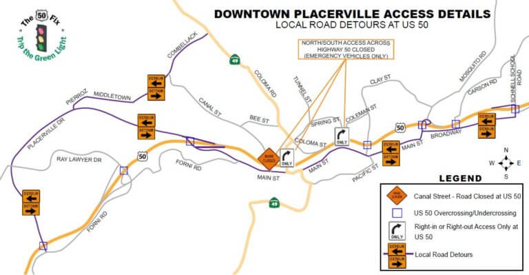
Advisory: Placerville Traffic Alert Due to evacuations from the CALDOR fire, expect traffic delays on westbound HWY 50. Avoid the area if possible.
Due to evacuations from the CALDOR fire, residents from the Pollock Pines area will be traveling on westbound Highway 50. Expect traffic delays and congestion on westbound Highway 50 and surface streets. Please avoid the area if possible. Manual traffic control or Trip-to-Green may be implemented on Highway 50. Officers WILL NOT allow cross traffic at these times. Please be patient during this emergency.
MANDATORY EVACUATIONS:
Pollock Pines – East of Sly Park Road. South of Hwy 50 up to Ice House Road. North of Mormon Emigrant Trail (including Jenkinsons/Sly Park Road)
EVACUATION WARNINGS:
South of Hwy 50 to Pleasant Valley Road. From Sly Park Road, west to Snows Road and Newtown Road, including the community of Rancho Del Sol.
EVACUATION CENTER:
Diamond Springs Fire Hall is FULL. Please go to Cameron Park CSD
Cameron Park CSD, 2502 Country Club Drive, Cameron Park, CA 95682
LARGE ANIMAL SHELTER
Amador County Fairgrounds, 18621 Sherwood Street, Plymouth, CA 95669 (Empire Street Gate)
SMALL ANIMAL SHELTER: Call 530.621.5795
Campers have been evacuated from Sly Park Recreation Area/Jenkinson Lake.
For the most current information on the status of the Caldor Fire to include maps and evacuations, we recommend accessing the links listed below. The Caldor Fire Information line is also very useful and provides recorded updates.
Caldor Fire Information Line: (530) 303-2455
Caldor Fire Maps: inciweb.nwcg.gov/incident/maps/7801/
Email: Enfincident@gmail.com
Inciweb: inciweb.nwcg.gov/incident/7801/
Facebook: www.facebook.com/eldoradonf
Twitter: twitter.com/EldoradoNF
Wildfire Cameras: www.alertwildfire.org/tahoe/